
inprogress
Solaria has continental dimensions: its emerged lands measure approximately 9.9 million km² and are home to approximately 740 million inhabitants, with an average density of 75 inhabitants per km². In extent, population, and density, the island is comparable to Earth’s Europe.
The scale of the map
The map of Solaria shows a graduated scale bar from 0 to 60 without units of measurement. The measurements in this entry read each unit of the bar as 3 km: the entire bar is thus worth 180 km. With this reading, the island extends for about 5,400 km from west to east, from the Sea of Ryndor to the Iridium Sea, and for about 4,300 km from north to south, from the northern coast of Eos to the southern cape of Theknus.
The surface areas of the nations have been measured on the map; that of Altaluna includes the contested border strips, hatched on the map.
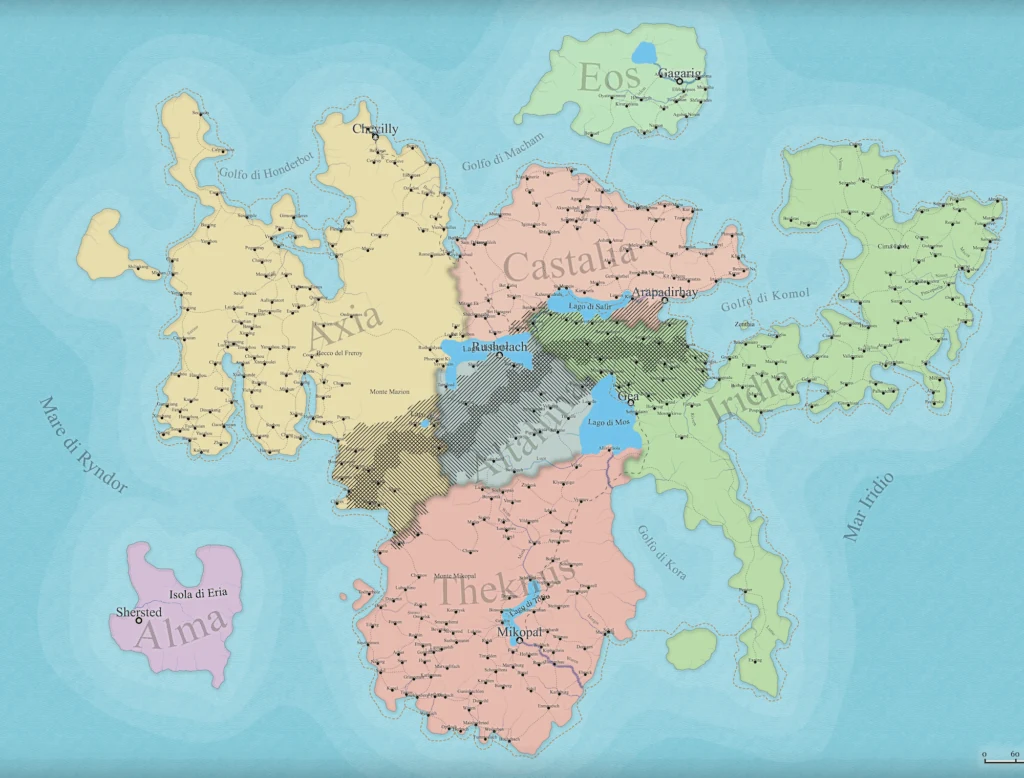
The map of Solaria: the scale bar in the bottom right, from 0 to 60, corresponds to 180 km.
The nations
| Nation | Surface Area | Inhabitants | Density | Urban Population | Capitals |
|---|---|---|---|---|---|
| Axia | 2,490,000 km² | 199 million | 80 inhab/km² | 78% | Nexus, Mugen |
| Theknus | 1,970,000 km² | 177 million | 90 inhab/km² | 80% | Yantra, Sankofa |
| Castalia | 1,060,000 km² | 117 million | 110 inhab/km² | 82% | Amal, Qo |
| Iridia | 1,990,000 km² | 109 million | 55 inhab/km² | 55% | Prahna, Gea |
| Altaluna | 1,450,000 km² | 87 million | 60 inhab/km² | 58% | Nuru, Qamar |
| Eos | 510,000 km² | 36 million | 70 inhab/km² | 70% | Ruah |
| Alma | 390,000 km² | 12 million | 30 inhab/km² | 45% | Alma |
| Solaria | 9,860,000 km² | 737 million | 75 inhab/km² | 73% |
The distribution follows the vocation of each nation. Castalia, land of communication, is the densest and most urban: language needs encounter. Theknus concentrates its population around the production districts and the inland routes. Axia is the largest and most populous nation, articulated in peninsulas and gulfs along which university cities and research centers line up. Iridia and Altaluna remain predominantly rural: the former by vocation, the latter also due to the war, which has emptied its border strips. Alma, a remote island surrounded by the Horizon of the Manifold, is the least inhabited land.
The twelve capitals
The twelve capitals are symbolic cities before being demographic ones: they do not always coincide with the largest city of their nation. The table shows the population of the metropolitan areas.
| Capital | Nation | Metropolitan Area |
|---|---|---|
| Nexus | Axia | 9.8 million |
| Amal | Castalia | 5.4 million |
| Yantra | Theknus | 4.6 million |
| Qo | Castalia | 3.6 million |
| Mugen | Axia | 3.1 million |
| Sankofa | Theknus | 2.6 million |
| Nuru | Altaluna | 2.4 million |
| Prahna | Iridia | 2.3 million |
| Ruah | Eos | 2.3 million |
| Qamar | Altaluna | 1.7 million |
| Gea | Iridia | 1.4 million |
| Alma | Alma | 0.85 million |
Nexus, the bond, is the largest city in Solaria: the node where the scientific networks and communication routes of the north converge. Yantra is the third largest metropolitan area on the island and the largest in the Southern League.
Hierarchy of settlements
The settlements of Solaria are divided into five tiers. For cities, the population is that of the entire urban area, suburbs included.
| Tier | Inhabitants | Number | Total Population |
|---|---|---|---|
| Metropolises | over 2 million | 27 | 86 million |
| Large cities | 500,000 to 2 million | 135 | 121 million |
| Cities | 100,000 to 500,000 | 600 | 121 million |
| Towns | 10,000 to 100,000 | 8,250 | 206 million |
| Villages and hamlets | under 10,000 | about 101,500 | 203 million |
| Total | about 110,500 | 737 million |
By nation
| Nation | Metropolises | Large Cities | Cities | Towns | Villages and Hamlets |
|---|---|---|---|---|---|
| Axia | 8 | 37 | 170 | 2,300 | 22,000 |
| Theknus | 7 | 36 | 160 | 2,200 | 17,500 |
| Castalia | 6 | 23 | 100 | 1,400 | 10,500 |
| Iridia | 3 | 16 | 70 | 1,000 | 24,500 |
| Altaluna | 2 | 14 | 60 | 850 | 18,500 |
| Eos | 1 | 7 | 30 | 400 | 5,500 |
| Alma | – | 2 | 10 | 100 | 3,000 |
The metropolises of Axia, Theknus, and Castalia also include the two capitals; Gea, Qamar, and Alma are large cities.
Related entries
The Seven Nations
The Twelve Capitals
Yantra
Southern League
Northern Alliance